
By: Anusheema Chakraborty, Barney Chesher, Fawzi Dibis and Nivine Issa
Date Published: November 4, 2019
Urbanization, boosted stress on natural resources and the ever-expanding demand on infrastructure are some of the many reasons cities have a greater vulnerability to disasters, anthropogenic changes and climate alterations. Poorer communities are often more vulnerable due to them inhabiting more hazard-prone areas and lacking essential contingencies to withstand and recover from economic and environmental shocks. 3 million people move globally into cities every week and projections show that at least 2.5 billion residents will inhabit urban areas by 2050, it is therefore primordial that governments invest in urban resilience programs for future- proofing their cities.
“A resilient city is one that assesses, plans, and acts to prepare for and respond to all hazards, either sudden or slow-onset, expected or unexpected” (UNH, 2019). Achieving urban resilience necessitates planning a city at a macro- level, understanding interdependencies of its systems and mitigating for the risks they may face.

Hazards facing cities could result from chronic stresses such as a struggling public transportation system and food and water scarcity as well as acute shocks such as earthquakes and floods. Climate change impacts for instance can be detrimental on cities but can be alleviated by strengthening interdependent infrastructure systems and ensuring resilience on an infrastructure, policy and economic basis.
In fact, the work on a new ISO international standard for Urban resilience, led by the United Nations, has just begun, which aims at helping governments build safer and stronger urban environments. This standard will help define a framework that will help governments identify, implement and monitor appropriate actions to become more resilient (ISO, 2019).
Resilience is an ongoing and iterative process which recognizes that vulnerability and climate risk are constantly evolving, as our cities and communities evolve and interact. Climate resilience is achieved when short, medium and long-term decision making considers current climate risks and a changing climate.
There are four components of urban resilience based on the categorization established by Jha, et al., 2013:
This article discusses key climate change impacts observed on a global scale and the design implementations that can be incorporated to be more resilient against different climatic events that occur as a result of global warming and climate change. This article focuses on four key areas: extreme weather events, flooding and sea level rise, deforestation and land degradation and the global increase in urban temperatures.
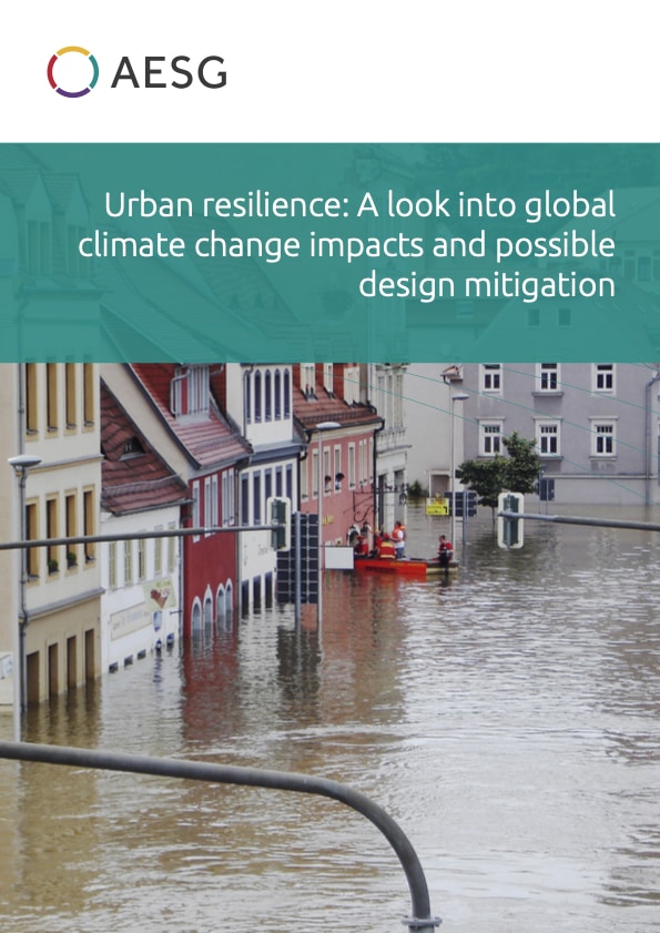
Flooding can be categorized as a disaster occurrence, where an area or land that is normally dry, abruptly becomes submerged with water. This can happen in a multitude of ways; as a result of overflow of water from extreme rainfall events or even flash floods, or exceeding flow-rates in rivers, lakes, or other waterbodies/reservoirs, and subsequent spreading over adjacent land (i.e. flood plain), or it could be also prevalent in coastal cities due to large storms or tsunami-related events causing the sea/ocean to surge inland1.
Climate variability and climate change impacts have led to dramatic increase in the global frequency as well as intensity of flooding-related disasters (Bai et al., 2018). Floods in urban areas usually occur during brief and intensive rainfall events in densely populated areas with insufficient drainage and sewer systems, known as pluvial floods (Torgersen and Navrud, 2018). On the other hand, overflowing rivers within or adjacent to the cities are regarded as fluvial floods, which are among some of the costliest natural disasters around the world (Dottori et al., 2018). In certain cases, the co-occurrence of fluvial floods and extreme coastal water levels (i.e. sea-level rise) lead to compound flooding, causing significant impacts in the lower elevation coastal cities (Ganguli and Merz, 2019).

In June 2013, Alberta, Canada experienced catastrophic floods, with a death toll of up to 4 people from drowning, and displacement of 100,000 residents as a result of the rising water levels (Figure 2-2). It washed away one-quarter of the province right through the heart of Calgary – the fourth largest city in Canada2. Up until the 2016 Fort McMurray wildfire, this event was considered to be the costliest natural disaster in Canada, with an estimated total cost of property damage around $5 billion Canadian dollars3.

Another example is the aftermath of severe floods that affected millions in the south Indian state of Kerala (Figure 3). From the onset in the month of May in 2018, unusually high rainfall during the monsoon season led to the death of 438 people, and around 140 people were declared missing. This once-every-100-years flooding event forced about a million people out of their homes (Padma, 2018).

The unusual downpour caused rivers in the state to overflow, along with unfortunate release of the states’ 44 dams, where reservoirs were close to overflowing, which wreaked even more havoc in the downstream areas of the region. Earlier in the year, in January and February 2019, after eight days of continuous heavy monsoonal rainfall, authorities in north Queensland, city of Townsville, Australia, had no choice but to open the floodgates of the Ross River Dam, flooding about 2,000 homes.

Very recently, in the month of September 2019, more than 2 inches of rainfall was recorded in less than 12 hours in some areas of London, United Kingdom. Five flood warnings and 40 flood alerts remain in place across the country by the Environment Agency for the city of London and its suburbs1.

Another major impact observed due to global warming is the melting of ice sheets of Greenland and the Antarctic, which has increased substantially over the last couple of decades2. This has a critical impact on global sea levels, and accounts for coastal flooding around the world. It is one of the most severe impacts of climate change, as rising waters threaten to inundate small-island nations and coastal regions by the end of the century3.
Figure 2-6 depicts the contribution of different factors to global sea level rise between 1993 and 2018. The primary factors shown are added water and thermal expansion and a combination of both. The infographic shows that the combination of added water (mostly meltwater) and thermal expansion have directly contributed to the recent increase in global sea level rise.

It has been estimated that by 2050, over 570 low-lying coastal cities will face sea level rise by at least 0.5 meters, thereby, putting up to 800 million people at risk as a result of rising seas and oceans, as well as storm surges1. In 2018, according to the State of the Climate Report, global mean sea level was 3.2 inches (81 millimeters) above the 1993 average—the highest annual average in the satellite data record (1993-present)2.
Figure 2-7 depicts the cities at risk from 0.5 m sea level rise by 2050. The cities are spread across the globe, however, the majority of the largest populations at risk are in the ‘Global South’ (low- and middle- income countries located in Asia, Africa, Latin America and the Caribbean). This is an example of the disproportionate impact of climate change, with poorer nations often facing the brunt of impacts.

Due to competing predictions of future global temperatures, there is no common consensus on exactly how fast or high sea levels will rise; however, scientists in general agree on its principle impacts, such as: (a) submergence and flooding of coastal land, (b) saltwater intrusion into surface waters and groundwater, (c) increased coastal erosion, and (d) other negative social and economic repercussions3.

As shown in Figure 2-8 above, the North Sea continues its relentless erosion of the coast near the small English town of Happisburgh, United Kingdom. The previous coastal defenses are largely ineffective in this area. In this picture, a Second World War bunker has fallen from the eroded cliffs, while elsewhere along the coast, homes have already been lost to the sea1
Another example is New York City (NYC) in the United States, as the city is located in a flood-prone area due to rising sea levels. New York has experienced at least 12 inches of sea-level rise since 1900, mostly due to expansion of warming ocean water2. As per scientific research, sea-level rise could be up to 18 to 50 inches higher than today along New York’s coastlines and estuaries. Lately, climate-focused infrastructure efforts are being initiated as part NYC’s coastal resilience efforts, potentially costing up to $10 billion US dollars3.

In lower-income countries, such as the Indonesian capital, Jakarta, matters are much worse. The city is home to 10 million people and is also among the fastest-sinking cities in the world1.

In northern Jakarta, more than 60 percent of the city’s population live in poor, informal, high-density settlements, thereby, being highly vulnerable to coastal flooding. Located on a marshy land, the Java Sea lapping against it, and 13 rivers running through the city, Jakarta was frequently flooded in 1976, 1990, 1996, 2002, 2007 and 2012, and is facing similar issues even today. Moreover, illegal digging of wells is deflating the city from below, while increasing urban sprawl is adding additional pressure in the city, causing land to sink by 20 to 25 cm every year2.
A similar situation can be seen in Dar es Salaam, the largest city in Tanzania. With an estimated 8 percent of the city already below sea level, the city’s vulnerability is heightened by not only sea level rise and coastal flooding, but also due to poor sewerage and inadequate drainage systems. In Dar es Salaam, infrastructure assets valued at US$5.3 billion are increasingly at risk from flooding and sea level rise4.
Urban resilience: A look into global climate change impacts and possible design mitigation
As per the IUCN issue brief, deforestation and forest fragmentation are regarded as the biggest threats to forests around the world1. Deforestation usually occurs when forests are converted to other non-forest uses. While not all deforestation is intentional, some could also be caused by a combination of anthropo-genic and natural disturbances, such as forest fire and overgrazing, which limits the growth of young trees (Chakraborty et al., 2017). Forest degradation could also occur due to multitude of factors such as land clearing, illegal tree felling and logging, forest fragmentation, farming, grazing of livestock, mining, and drilling, and other human-linked activities; but essentially, it can be described as, forest ecosystems losing their capacity to provide essential ecosystem goods and services (Silvério et al., 2019).
According to the World Bank2, about 30% of the world’s land area is covered by forests. However, they are disappearing at an alarming rate; over a quarter of global forest loss is due to deforestation through permanent land use change for the production of commodities, including beef, soy, palm oil, and wood fiber (Curtis et al., 2018). In the last 25 years (between 1990 and 2016), the world has lost 1.3 million km2 of forest, which is approximately larger than the size of South Africa3. Up to 46 percent of trees have been cut down since the start of civilization (Crowther et al., 2015). Figure 3-1 depicts the change in forest area by country since 1990. There is a clear difference between the Global North and the Global South; the USA and Europe saw an increase in forest area while typically South America and Africa lost forestry area.

Deforestation affects human beings as well as animals. Over 80% of the world’s terrestrial biodiversity can be found in forests5. The loss of forests will threaten the survival of numerous species (Symes et al., 2018), and also reduce the forests’ ability to sustain provisioning, supporting, regulating and cultural services (Ferraz et al., 2014). Moreover, forests absorb 2.4 billion tonnes of carbon dioxide (CO2) per year, one-third of the annual CO2 released from burning fossil fuels; thereby proving crucial for mitigating climate change impacts6. Furthermore, they act as support for food safety during climate shocks, reduce risks from disasters such as coastal flooding, and help regulate water flows and microclimates within both urban and rural ecosystems.
Since 1978, over 750,000 km2 of Amazon rainforest have been destroyed across Brazil, Peru, Colombia, Bolivia, Venezuela, Suriname, Guyana, and French Guiana1. Cattle ranching is the largest driver of deforestation in every Amazon country, accounting for roughly 80% of the current rates of deforestation2.

In Malaysia and Indonesia, rainforests are being cut down and degraded for timber, palm oil, pulp, rubber and other minerals5. Some of the recent deforestation has occurred in west and central Africa6. In fact, degradation of forests has already transformed some areas into savanna grasslands or degraded savannas.

In Asia, nearly one-third of the forests have been lost in the last 35 years in five Asian countries1. More so, WWF claims in a 2013 report that in countries such as, Cambodia, Laos, Burma, Thailand and Vietnam, given the current deforestation rates, forest could be left with less than 10-20% of their original cover by 2030, with devastating effects on wildlife and people2.
Another environmental problem is land degradation and desertification, which is undermining the well- being of two-fifths of the global population, raising the risks of migration and conflicts3. In fact, more than 75 percent of the Earth’s land areas are substantially degraded. IPCC’s latest report comprehensively discusses the impacts of climate change on desertification and land degradation4.
Furthermore, wetlands around the world have been degraded the most, with 87 percent lost globally in the last 300 years, and some 54 percent lost since the 1900s5. Specifically, coastal wetlands have experienced major loss of area and subsequent ecological functions, and continue to face worldwide challenges due to coastal development and global climate change (Lin and Yu, 2018).
In Uganda, wetlands have declined from an estimated 13% of the total land area in 1994 to 10.9% in 2008 (Nsubuga et al., 2014). This is mainly due to clearance and subsequent conversion of wetlands into other land uses. This is coupled by compounding factors such as, prolonged droughts, frequent flooding, soil erosion and siltation, mainly in the Western Ugandan region.


In other instances, land degradation takes form of desertification. For instance, China is severely
affected by desertification as more than a quarter of its territory is covered by desertified habitats. Various factors, both environmental conditions and human interference can be accounted for; however, climate change is making matters worse1.

Most Arab countries in the Middle East have insufficient water resources, making the region more prone to desertification and droughts. In the Arabian Peninsula, the land is threatened by desertification ranges from 70 to 90 percent3. For instance, Israel and the southern marshlands of Iraq are expected to experience significant decrease in biological productivity, which is a major indicator for dryland degradation. Agricultural expansion and urban development are the major causes for dryland degradation and soil salinization in Israel4.
According to Food and Agricultural Organization of the United Nations (FAO)5, the eastern sub-region (Iran, Iraq, Jordan, Lebanon, Sudan and Syria) is most affected by land degradation. The extent of degradation in the countries of the Middle East are very high, being considerably higher in Iraq (72 percent) and Syria (70 percent), than in the Gulf Countries such as Oman (50 percent), Qatar (25 percent), and Bahrain (20 percent). In fact, a single farming system can majorly influence the process of land degradation in this region6.
Deforestation and land degradation result in stresses on the built environment, from the increase in the number of people having to migrate into urban areas, through disruption to ecosystem services, worsened flooding events and more severe droughts.
Urban resilience: A look into global climate change impacts and possible design mitigation
Severe weather conditions refer to any meteorological event which has the potential to cause damage, serious social disruption or loss of human life. Extreme weather events refer to weather conditions at the extremes of the historical distribution. Extreme weather events typically include periods of extreme tem- perature, droughts, floods, wildfires and storm events such as cyclones and hurricanes.
Changes in the pattern and intensity of extreme weather events are, and will continue to be, the primary way most people experience the effects of climate change (NCA, 2014). Changes in extreme weather have been observed globally: there has been a substantial increase in most measures of Atlantic hurricane ac- tivity since the early 1980s (Bell & Chelliah, 2016), UK heatwaves have increased two- to threefold since the late 1800s (Chapman, Watkins & Stainforth, 2019) and the Sahel region has had several unusually pro- longed and severe droughts over the past sixty years (Simpkins, 2018).
The interaction between a changing climate and extreme weather events can be simple or more complex, depending on the weather phenomenon:
Urban resilience: A look into global climate change impacts and possible design mitigation
A devastating heatwave hit Europe in July 2019, immediately following the June 2019 European heatwave. The July heatwave between 21 – 28 July 2019 set all-time high temperature records in Belgium, Germany, Luxembourg, the Netherlands and the United Kingdom. The French Ministry of Health reported that 1,500 people died in France as a result of the summer heatwaves1, with most of those who died were aged over 752.
Apart from human life losses there were also financial and social implications as a result of the heatwave, as the built environment struggled to deal with the prolonged, increased temperature. Two nuclear reactors in southwest France were shut down and the output of six reactors were curtailed to avoid breaching environmental limits on the temperature of the rivers they use for cooling water. This reduced French nu- clear power generation by around 5.2 gigawatts at a time of increased electricity demand due to the use of air conditioning units. Nuclear plants in Germany also had to cut power output3.
In the UK, the National Rail imposed speed restrictions across its network to reduce buckling rails, as track temperatures neared 60 °C4. Many heat-related incidents on the rail network caused widespread disruptions. All Eurostar services to and from Paris were also suspended for an undetermined time period due to an exploded cable, as well as delays lasting up to an hour on Brussel`s services5. Several flights were can- celled and delayed from Heathrow, Gatwick and London City airports due to extreme weather conditions across Europe.
A study found that the temperatures experienced during the heat wave would have been 1.5 to 3 °C lower had it not been for anthropogenic global warming, and that temperatures recorded in France and Nether- lands would have occurred there on average less than once a millennium (Vautard, 2019).
According to Vautard (2019), at the current pace of waring, such heatwaves will be another 3 °C higher in temperature by 2050.
Between late August and early September 2019, Hurricane Dorian primarily struck the Bahamas, with other affected areas including the East Coast of the United States and Eastern Canada. The tropical cyclone was the most powerful on record to strike the Bahamas and was the worst natural disaster in the country’s history. The hurricane caused over an estimated $8 billion USD of damage and resulted in over 63 confirmed deaths with over 1300 still missing. The UN report that 76,000 have been left homeless after the event1.
Climate change made Hurricane Dorian more damaging. The local sea level is around 0.2 m higher than normal as a result of climate change and this results in more damaging storm surges. Increasing sea temperatures also caused a more damaging weather event. Hurricanes gather their energy as they move over water and are fueled by warm surface waters. Dorian moved over waters up to 1 °C warmer than normal and intensified at an unprecedented rate for an already strong storm, with wind speeds going from 240 to 300 kph in less than 9 hours2.
Similar events have been experienced around the world. In May 2018, Cyclone Mekunu struck Oman, becoming the strongest storm to hit Oman’s Dhofar Governorate since 1959. While passing Socotra, the Cyclone dropped heavy rainfall, causing landslides and flooding that killed 20 people. In eastern Yemen, power outages as a result of the cyclone resulted in four deaths, while in Oman the cyclone was responsible for seven deaths and around US$1.5 billion in damage.
Climate change means that hurricanes are expected to intensify faster, to become stronger, to release more rain and to move slower. These factors make storms far more damaging as wind damage rises exponentially due to increase in wind speeds and slower storms can release far more rain in one area. With continued changes in global climate, the threat of cyclone and hurricane impact on the built environment will continue to grow.
Urban resilience: A look into global climate change impacts and possible design mitigation
With the continued global trend of urbanization, it is important to understand the relationship between urban areas and temperature. The UN project that 68% of the world’s population will live in urban areas by 2050, as opposed to 55% in 2018 (UN, 2018). With more people than ever to be living in urban areas, and an increasing global climate, the threat of increased urban temperatures has never been higher.
The explanation as to why cities and urban areas experience higher temperatures lies within the materials used to build a city, the architecture, and how materials in the built environment interact with heat and solar radiation when compared to the materials found in a rural area.
Climate change leads to higher temperatures and longer, more severe, and more frequent heat waves. Urban areas already suffering from the heat island effect will bear the brunt of these harsher heat events. An increase in urban temperatures threatens urban resilience in a multitude of ways. The increases in urban temperatures will be increasingly harmful to people’s health and the air and water quality in our communities.
Heat also causes economic losses, with impact on labour productivity due to lost labour hours. The International Labour Organization (ILO) warned that lost labour output due to heat stress could equate for 2.2% of total working hours worldwide in 2030 and cause a loss to the global economy of $2.4 trillion a year1. The report defines heat stress as occurring at temperatures above 35 °C, in places where there is also high humidity. The two industries which will feel these impacts the greatest are agriculture and construction, with construction losing an estimated 19% of global working hours by the end of the next decade.
The increase of urban temperatures, both in general and in comparison to the rural surroundings, is occur- ring on a global scale. In the summer of 2012 the capital of Wisconsin USA, Madison’s urban areas experienced up to twice as many hours ≥32.2 °C as its rural counterparts, a mean July maximum temperature up to 1.8 °C higher, and a mean July minimum temperature up to 5.3 °C higher than rural areas (Schatz, and Kucharik, 2015).
Jacobabad, Pakistan regularly surpasses 50 °C in the summer months, with elder residents claiming that the increase in heat is a recent phenomenon, with fond memories of cooler days2. The heat makes day to day activities difficult, however, residents know that if they do not work through the summer heat, they will not be able to support their families.
The average temperature in Las Vegas rose 4 °C in just four decades (1970’s – 2000’s). The largest temperature increase corresponds to the largest increase in population, with over one million people relocating to the Las Vegas Valley during the same timeframe (City of Las Vegas, 2010). As the population increased so did the demand for new infrastructure (roads & highways) and structures (residential & commercial). These new impervious surfaces absorb and radiate heat, resulting in an increase in the average temperature. Climate Central (2014) investigated the urban heat island (UHI) effect in several US cities and found Las Vegas to have the most intense UHI. The study found a 13.3°C maximum difference between urban and rural areas, a 4°C average summer difference between city and rural temperatures, and that the urban area had 22 more days above 32°C than rural areas.
To overcome the challenges discussed earlier in this paper, planners, engineers, architects, and others in- volved in project delivery must use region-specific future projections in the realm of city planning. Hence, the planning process must be overhauled to integrate resilience principles at the earliest planning stages to ensure better results. In accordance with the United Nations Office for Disaster Risk Reduction (UNDRR, 2007), resilience is the ability of a system, community or society exposed to hazards to resist, absorb, ac- commodate and recover from the effects of a hazard in a timely and efficient manner, including through the preservation and restoration of its essential basic structures.
Urban resilience generally refers to the ability of a city or urban system to withstand a wide array of shocks and stresses. As such, climate change is understood as one of the many stresses that cities face. Although, resilience and adaptation are often linked, there is a clear distinction between the two concepts. MacClune & Optiz-Stapleton (2012) defines adaptation as discrete actions, such as building flood-protection systems or mangrove restoration, with discrete beginnings and ends, developed to address specific vulnerabilities or problems, whereas resilient systems are the stable, yet flexible foundations that people require in order to shift strategies and adapt as conditions change.
For city and municipal governments, resilience implies planning development; providing safe and af- fordable infrastructure and services; regulating building design and construction; regulating hazard- ous activities; influencing land availability and construction requirements; encouraging and support- ing household and community actions to reduce risk; and finally, putting in place effective disaster early warning, preparedness, and response systems.

The planning process starts with a risk assessment to identify a project’s overall level of climate change risk through assessing the probability that an impact will occur over the project’s lifetime and evaluating the consequence of such an impact. Drivers of risk include rapid urbanization, environmental degradation, development-related processes, and the effects of climate change. Risk information provides the basis for prioritizing risk reduction measures
According to Jha, et al. (2013) identified risks can be mitigated using risk reduction approaches directed to location, structure, operational capacity, and fiscal strength and exposure:
Locational approaches, as defined above, tend to be the most proactive. It is usually the result of proper consideration of urban resilience principles at early stages of the planning process. As you move down the list, the approaches tend to become more reactive and are often associated with additional costs.
In the following sections, we will be focusing on some of the innovative locational and structural approaches being implemented globally to address a myriad of urban challenges.
The built environment’s contribution to the urban heat island effect can be minimized for a reduced heat loading, reduced energy costs, and/or improved occupant health and thermal comfort. Climate-resilient public realm measures would strengthen community adaptability to climate change and mitigate the urban heat island effect through the creation of systemic, interconnected and protective micro-climates within the public realm, intended to reduce energy loads, produce cleaner air and enhance civic life. Many cities around the world have implemented various strategies and solutions to reduce UHI such as:
Doick, et al. (2014) found that a large park in London had night-time air temperatures which were up to 4 °C lower (average 1.1 °C) than those in built-up areas on calm nights.

At a regional scale, research shows that Californian street trees was predicted to lead to net annual energy savings (cooling and heating) of $101 million (McPherson, van Doorn, & De Goede, 2016).


Additionally, it is critical for design teams to consider the building’s design to improve indoor and outdoor user thermal comfort and consider future climate change impacts to ensure the building performs as intended throughout its lifetime.
The following strategies can be utilized:
More sophisticated software is increasingly available to determine micro-climate impacts of three-dimensional urban form. New metrics, design tools and workflows have been developed to translate regenerative design concepts into practice effectively and visualize results. These urban simulation tools assist planners and architects to evaluate a wide range of performance metrics simultaneously.

Additionally, evolutionary problem-solving algorithms are now available and employ trial-and-error methods in order to arrive at optimized results. When automated for specific parameters and results, this technique becomes an effective way to computationally drive controlled results within the iterative design process – allowing designers to produce optimized parameters resulting in a form and layout.
The adoption of comprehensive planning which considers long-range planning tools used to guide future development in a community is key to avoid the disastrous consequences of extreme weather events and sea level rise. The following measures can be followed to mitigate such risks

The City of Boston has prepared Climate Resilient Design Standards and Guidelines to address both acute and chronic flooding due to sea level rise (SLR) and storm surge to protect the public rights-of-way, multiple design prototypes were provided that would form the standard shore flood protection systems such as:


Regulatory measures complement the application of the above mitigation measures to look at zoning laws, floodplain management and building codes:

The Boston Harbor Flood Risk Model (BHFRM) is used as the basis for sea level rise information and design. The City of Boston Planning & Development Agency has developed a sea level rise layer in their zoning viewer using the BH-FRM and 2070 projections. The guidelines’ climate design adjustments are structured by “useful life” with projections for the 2030, 2050, and 2070 time horizons. This acts as a key planning tool for utilization throughout the City of Boston to strategize resiliency investments now and into the future.
UN-Habitat is the United Nations program working towards a better urban future. Its mission is to promote socially and environmentally sustainable human settlement development and the achievement of adequate shelter for all. One of UN-Habitat’s goals is to increase the resilience of cities to the impacts of natural and human made crises. UN-Habitat’s support to build urban resilience globally works along three complimentary streams:
Additionally, as part of the UN-Habitat urban resilience program, work has started on a new ISO standard for urban resilience, aimed at supporting national and local governments to build their capacity to face the new challenges arising from climate change and shifting demographics, as mentioned in the introduction of this article. It will define a framework for urban resilience, clarify the principles and concepts, and help users identify, implement and monitor appropriate actions to make their cities more resilient.
These programs are supporting cities to develop strategies that specify city specific resilience-building goals and articulate the actions, projects, and policies or “initiatives”. Measurable KPIs must be set for continuous monitoring and improvement. On that basis, cities begin identifying their priority initiatives based on intrinsic need and available resources. Notable cities with urban resilience strategies include Boston, New York and Rotterdam.
Based on the strategies, cities then start to develop governance structures to oversee the implementation, financing and development of all guidelines and standards required. An example would be the NYC Climate Resiliency Design Guideline which provides step by step instructions on how to supplement historic climate data with specific, regional, forward-looking climate change data in the design of city facilities. The Guidelines complement the use of historic data in existing codes and standards by providing a consistent methodology for engineers, architects, landscape architects, and planners to design facilities that are resilient to changing climate conditions. Similar guidelines exist in other global cities. In addition, professional bodies such as the International Code Council (ICC) and The American Society of Civil Engineers (ASCE) develop and issue standards that set technical standards for design of urban resilient structures. Flood Resistant Design and Construction (ASCE 24) is fully incorporated into New Jersey Building Code and serves as the basis for New York City Building Code Appendix G (Flood-Resistant Construction).
This article discussed only some of the global challenges that cities around the world are facing. Sea level rise and floods continue to have catastrophic impacts on urban populations, built assets and infrastructure worldwide, and urban ecosystems must be designed and better maintained to allow for a level of contingency should climatic, anthropogenic and environmental circumstances change over time. Similarly, sustainable farming and land management must be governed at policy level to avoid overgrazing and the loss of valuable forests, in addition to the integration of sustainable building guidelines into the design, construction and operation of built assets to alleviate the ever-increasing urban temperatures.
Urban resilience is a complex and an ever evolving subject and must be catered to each city’s challenges and environmental stresses. Some cities and counties from around the world have started planning for urban resilience and integrating such principles in their urban design plans, construction programs as well as operation and maintenance schemes of their infrastructure and utility systems.
As we continue to experience changes in climate patterns and as population sprawls continue to evolve, the repercussions of any natural disasters will continue to be catastrophic. Building resilience in cities is essential to not only make populations and infrastructure less susceptible to damage and loss but also be more agile to the unpredictable nature of climate change impacts.
Bai, T., Mayer, A.L., Shuster, W.D., Tian, G., 2018. The Hydrologic Role of Urban Green Space in Mitigating Flooding (Luohe, China). Sustainability 10, 3584.
Bell, G. D., & Chelliah, M. (2016). Tropical cyclones: Atlantic basin [in “State of the Climate in 2015”]. Bull. Amer. Meteor. Soc, 97(8), S105-S106.
British Columbia Ministry of Environment , 2013. SEA LEVEL RISE ADAPTATION PRIMER -A TOOLKIT TO BUILD ADAPTIVE CAPACITY ON CANADA’S SOUTH COASTS, s.l.: s.n.
Chakraborty, A., Ghosh, A., Sachdeva, K., Joshi, P.K., 2017. Characterizing fragmentation trends of the Himalayan forests in the Kumaon region of Uttarakhand, India. Ecological Informatics 38, 95–109.
Chapman, S. C., Watkins, N. W., & Stainforth, D. A. (2019). Warming trends in summer heatwaves. Geophysical Research Letters, 46(3), 1634-1640.
City of Las Vegas. (2010). Urban Heat Island Effect Summary Report.
Choe, K., Wassmouth, Z., Jayasinghe, P., Cording, A., Brizius, A., Mansfield, M., Pegan, A., Busch, C., Eaton, J., Groves, D. and Ricciardi, F. (2018). Climate resilient design standards and guidelines for protection of public rights-of-way. Boston: Boston public works department.
Crowther, T.W., Glick, H.B., Covey, K.R., Bettigole, C., Maynard, D.S., Thomas, S.M., Smith, J.R., Hintler, G., Duguid, M.C., Amatulli, G., Tuanmu, M.-N., Jetz, W., Salas, C., Stam, C., Piotto, D., Tavani, R., Green, S., Bruce, G., Williams, S.J., Wiser, S.K., Huber, M.O., Hengeveld, G.M., Nabuurs, G.-J., Tikhonova, E., Borchardt, P., Li, C.-F., Powrie, L.W., Fischer, M., Hemp, A., Homeier, J., Cho, P., Vibrans, A.C., Umunay, P.M., Piao, S.L., Rowe, C.W., Ashton, M.S., Crane, P.R., Bradford, M.A., 2015. Mapping tree density at a global scale. Nature 525, 201–205.
Curtis, P.G., Slay, C.M., Harris, N.L., Tyukavina, A., Hansen, M.C., 2018. Classifying drivers of global forest loss. Science 361, 1108–1111.
Doick, K., Peace, A. & Hutchings, T., 2014. The role of one large greenspace in mitigating London’s nocturnal urban heat island. Science of the Total Environment.
Dottori, F., Szewczyk, W., Ciscar, J.-C., Zhao, F., Alfieri, L., Hirabayashi, Y., Bianchi, A., Mongelli, I., Frieler, K., Betts, R.A., Feyen, L., 2018. Increased human and economic losses from river flooding with anthropogenic warming. Nature Clim Change 8, 781–786.
Dutton, A., Carlson, A.E., Long, A.J., Milne, G.A., Clark, P.U., DeConto, R., Horton, B.P., Rahmstorf, S., Raymo, M.E., 2015. Sea-level rise due to polar ice-sheet mass loss during past warm periods. Science 349, aaa4019.
Ferraz, S.F.B., Ferraz, K.M.P.M.B., Cassiano, C.C., Brancalion, P.H.S., da Luz, D.T.A., Azevedo, T.N., Tambosi, L.R., Metzger, J.P., 2014. How good are tropical forest patches for ecosystem services provisioning? Landscape Ecol 29, 187–200.
Ganguli, P., Merz, B., 2019. Extreme Coastal Water Levels Exacerbate Fluvial Flood Hazards in Northwestern Europe. Sci Rep 9, 1–14.
Jha, A. k., Miner, T. W. & Stanton-Geddes, Z., 2013. Building Urban Resilience-Principles, Tools, and Practice. s.l.:The World Bank.
Lin, Q., Yu, S., 2018. Losses of natural coastal wetlands by land conversion and ecological degradation in the urbanizing Chinese coast. Sci Rep 8, 1–10.
Losada, I. J., P. Menéndez, A. Espejo, S. Torres, P. Díaz-Simal, S. Abad, M. W. Beck, S. Narayan, D. Trespalacios, K. Pfiegner, P. Mucke, L. Kirch. 2018. The global value of mangroves for risk reduction. Technical Report. The Nature Conservancy, Berlin
MacClune, K. & Optiz-Stapleton, S., 2012. Building Urban Resilience to Climate Change:What Works Where, and Why, s.l.: ISET-International.
McPherson, E. G., van Doorn, N. & De Goede, J., 2016. Structure, function and value of street trees in California. Urban Forestry & Urban Greening, Volume 17.
Naboni, E., Natanian, J., Brizzi, G., Florio, P., Chokhachian, A., Galanos, T. and Rastogi, P. (2019). A digital workflow to quantify regenerative urban design in the context of a changing climate. Renewable and Sustainable Energy Reviews, 113, p.109255.
National Climate Assessment. (2014). US Global Research Program 2014.
Nsubuga, F.N.W., Namutebi, E.N., Nsubuga-Ssenfuma, M., 2014. Water Resources of Uganda: An Assessment and Review. Journal of Water Resource and Protection 6, 1297–1315.
NYC Mayor’s Office of Recovery and Resiliency, 2019. Climate Resiliency Design Guidelines – Version 3.0, s.l.: s.n.
Padma, T.V., 2018. Mining and dams exacerbated devastating Kerala floods. Nature 561, 13–14. Raven, J., 2011. Cooling the Public Realm:Climate-Resilient Urban Design, s.l.: s.n.
Schatz, J. and Kucharik, C.J., 2015. Urban climate effects on extreme temperatures in Madison, Wisconsin, USA. Environmental Research Letters, 10(9), p.094024.
Silvério, D.V., Brando, P.M., Bustamante, M.M.C., Putz, F.E., Marra, D.M., Levick, S.R., Trumbore, S.E., 2019. Fire, fragmentation, and windstorms: A recipe for tropical forest degradation. Journal of Ecology 107, 656–667.
Simpkins, G. (2018). Unprecedented Sahel drought. Nature Climate Change, 8(8), 662.
Symes, W.S., Edwards, D.P., Miettinen, J., Rheindt, F.E., Carrasco, L.R., 2018. Combined impacts of deforestation and wildlife trade on tropical biodiversity are severely underestimated. Nat Commun 9, 1–9.
Torgersen, G., Navrud, S., 2018. Singing in the rain: Valuing the economic benefits of avoiding insecurity from urban flooding. Journal of Flood Risk Management 11, e12338.
UNDRR, 2007. 2009 UNISDR Terminology on Disaster Risk Reduction, s.l.: s.n. UNEP-WCMC, 2014. UK National Ecosystem Assessment, Cambridge: s.n.
United Nations, 2018 Revision of World Urbanization Prospects produced by UN Department of Economic and Social Affairs (UN DESA)
Vautard, R. (2019). Human contribution to the record-breaking July 2019 heat wave in Western Europe.
Vaz Monteiro, M., Handley, P., Morison, J. I. L. & Doick, K. J., 2019. The role of urban trees and greenspaces, s.l.: s.n.